We know that the layout of roads in Sutton was very much the same in 1819 and in 1840 from the evidence of the Evanton Estate map of 1819 (Below) and the Tithe map of 1840 which has been helpfully put online through the National Library of Wales . Both show the staggered cross roads which may be thought of as dividing the village roughly into quarters. The same maps also show the branch lane off up to Sutton Mountain.
If we describe the layout in the four quarters.
South West quarter.
This is where today we have Westhill Fold Farm and Bass House. These appear later in the century and seem to have been built for James Eaton Evans (LINK).
On 1840 the tithe map shows two houses or homesteads at this location to the east of the road (called the Little Haven road on the 1818 map). In 1818 the land here was shown as Bounty Land – so purchased by funds from the Crown with the rent going to the church. By 1840 the land was owned by The Rev’d William Thomas and the Rev’d William Richardson.

North west quarter
This is where today there is the bus shelter and the five ‘new’ houses built onto a farm yard in the 1980s. In 1840 the tithe maps shows two significant farms based here, one of them close to the present crossroads and one set back with a driveway or lane approaching it from the crossroads. The 1818 map shows these houses as owned by Sir John Owen (so part of the Orielton Estate) and by Lord Milford (So that would have been part of the Picton Castle Estate). By 1840 the farms were owned by Anne Thomas and Ann Evans.
North East quarter
This is the area today with Sutton House, Can y Coed, the School House and the houses up to and including Margam View.
The 1819 map shows a long house perpendicular to the Nolton Road roughly where Sutton House is now with a small building in front roughly where the Sutton House gate is today and another building to the north on the roadside. (A building at roughly that location was knocked down in the 1980s).
There is no sign on either map of the school buildings (though there is a record of a school at Lambston at the end of the eighteenth century) or indeed any indication of buildings between the Sutton House buildings and the back entrance to Bramble Hall (Bramble Hill in 1840). On the 1818 map the field where the School Teacher’s house is today seems to be called ‘Nancy Knee’ thought the wording in not clear.
South East quarter.
This includes the area which presently features Westfold Cottage, Gabriel House and Thimble End. (the last rather wonderfully named by Billy Russell who had it built and moved there from Gabriel House in the 1990s).
This is shown with only one building on it on the Tithe map – that being a long building parallel to the road roughly where Westfold Cottage is today and shown as a Methodist Meeting House. This is rather surprising in that the Weslyan Meeting House at Providence is also shown (Though not named) on the same 1840 map. The 1819 map is rather indistict in this area but gain shows a single long narrow house parallel to the road and also shows a ‘pound’ just to the east of the house – beside the stream.
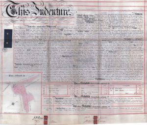
An estate sale document for Sutton farm in 1869 also gives an idea of the detailed village layout
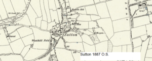
The land to the south is once again shown as ‘Bounty Land’ By 1887 the OS map shows a school and names Westhill Fold Farm – it shows a well on the corner below the old School House and another at Bramble Hill (Now Bramble Hall) and a post box in the village centre.