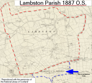
Lambston parish was merged with Camrose Community Area by the 1987 Preseli (Communities) order. This website only deals with the pre-1987 boundaries. The boundaries of parishes may well derive from the boundaries of manors so some of the parish boundaries may be 900 years old. There may have been unrecorded changes in the boundary over that time.
Temperness; sometimes Lambston sometimes St Thomas
In 1934 the Temperness land south of the Haven Road was transferred from St Thomas to Lambston Parish. The boundary then struck south east from the Rosemoor junction and rejoined the Haven Road only at Temperness Lane. This part is also now included within the Camrose Community Council area.
On the Tithe map in 1840 the southern boundary of Lambston runs up the Haven Road from the south-west corner of the parish. At that time the land associated with the Temperness Farms was shown as part of a detached portion of Haverfordwest, St Thomas parish. The map above shows both Lambston and the detached portion of St Thomas which was, from time to time, part of Lambston. (Sourced from Genuki website). In 1840, the land east of Temperness Lane was part of Poorfield Common.
Although all of the early Ordnance Survey maps show Temperness as in a detached portion of Haverfordwest St. Thomas, some older references also describe the land as in Lambston parish. For example;
Owen’s Penbrokshire, vol. 1, p. 61. 28. 1603 Pembrokeshire records, part 1, p. 122. 29. South Wales and the March, p. 140, n.5, and p. 141, n.2. 30. On farms held in severalty there was often a group of small, intensively-cultivated fields grouped around the domestic buildings and outhouses, while beyond them extended larger, rougher fields which merged into areas of waste. Good examples of such farms are furnished by Temperness in the parish of Lambston, and by Hayguardhay in Steynton parish.
Reference https://journals.library.wales/view/1041698/1041847/26#?cv=26&m=2&h= lambston
For the purposes of this work I will focus on the wider parish boundary – as described below – though I may stray if I find something interesting over the line!
Perambulation of the Parish Boundary
Starting in Portfield Gate and going anti-clockwise;
Eastern Boundary
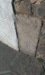
The boundary starts just east of the junction of the Sutton Road with the main Broad Haven Road (B4341). Here (Picture below) there is the one of only two parish boundary stones that I have been able to find. The readable inscription indicates it is also a O.S. Bench Mark. Does anyone recall the stone when the script was readable?
The boundary passes almost due north to East Hook Woods and then along the stream to join the Pelcomb Brook just south of the A487 St Davids -Haverfordwest road. This is the eastern boundary of the parish with St Martins. Interestingly where it follows the wood, the boundary is shown as ‘centre of fence’ rather than ‘centre of stream’ on the 25 inch maps. This suggests to me that the hedge at the base of East Hook Woods may be as old as the parish boundary.
Northern Boundary
The boundary turns west along the Pelcomb Brook to just south of Dunston Grove. It then follows a tributary stream upstream in a north-westerly direction to join the Lambston-Pelcomb Cross road, south of East Dunston. It passes along a surprisingly consistent line of field boundaries roughly on an East-West bearing. This line follows the watershed between the Pelcomb Brook and Knock Brook. This is the boundary with the old Camrose Parish.
The boundary turns north just to the north of Upper Honey Hook creating a rather odd peninsula of parish (About 8 fields, that in 1840, comprised a farm called Giberalter sic.). This pokes north into the joining corner of the adjacent three parishes of Camrose, Roch and Nolton. I wonder if Giberalter Farm was named because it was an intrusion into the neighbours’ territories – probably fanciful. There is no evidence of a farm at Giberalter on OS maps from 1887.
Western Boundary
After cutting west around the north of Giberalter, the boundary passes mainly in a southerly direction to the west of Upper Honey Hook. A boundary stone is shown on the OS map where the boundary crosses the Sutton-Nolton road just North West of the Honey Hook drive. I have not been able to find it in the hedge but it is recalled by long-standing residents. The boundary turns east on the Pelcomb Brook for one field and then strikes back south on a very continuous field boundary line. (See Photo below). Crossing the Rogeston Lane, it passes west of Sutton Mountain and joins the Rosehill road just west of its junction with the B4341.
This line seems unusually straight given it is in irregular fields and topography. I wonder if the boundary itself has some earlier significance – was it chosen for a reason or simple administrative convenience? Field boundaries are not usually shown on the smaller-scale OS maps but on the 1818 1″ map this boundary is shown as a single black line. Perhaps it marked the edge of the common when it was of a greater extent? I wonder if anyone who owns adjacent land might know something about this boundary. Does it seem older than similar field boundaries in the area? Is it more massive? Or more varied in terms of trees and shrubs? (Sometimes this denotes a particularly old boundary).
Anyway I am diverting from my perambulation of the parish!
Southern Boundary
The boundary turns East, follows the B4341 for a few hundred yards then to the road junction with the lane to Ratford Bridge. Here there is another boundary stone in a gateway, shown on map below.
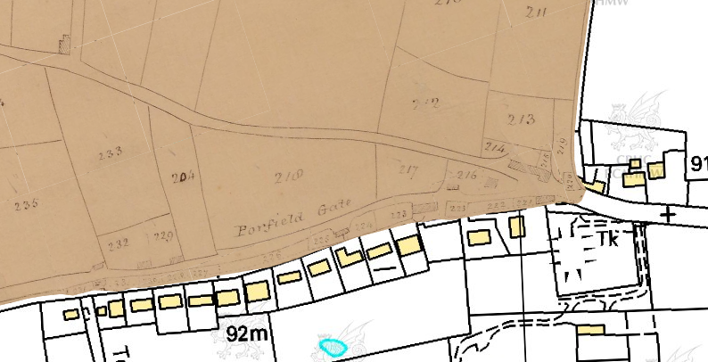
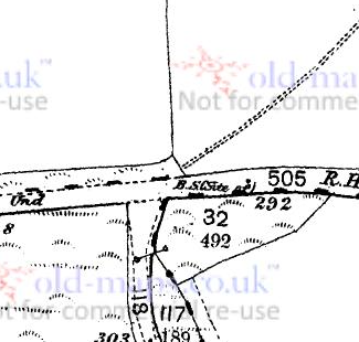 The boundary of the extended parish (Including Temperness), passes south and east following two different tributaries of the Merlin’s Brook. The only time that the parish is out of the Pelcomb Brook catchment. It meets the Temperness Lane at the wonderfully named ‘Peepout’ (I hope it is as interesting as it sounds). Here it cuts back north to meet the B4341 again. In Temperness Lane there are two ‘stones’ marked on the OS 25 inch maps. They could be boundary stones but see my little bit of detective work on this in “The Riddle of the Stones” in the PDF below.
The boundary follows a line just to the south of the Haven Road (and so including part of the line of new houses to the south of the road within the parish) to link back to where we started at the top of the page. Even when the Temperness land was excluded from Lambston, the boundary included those few houses which existed along the south of the Haven Road. These, in 1840, included a Parish Poor House just to the east of the Temperness Lane and in 1887 the New Inn.
The Riddle of The (Temperness) Stones is at this link