Mills in Lambston Parish
There were two mills in Sutton in 1598 and 1611. This is in an article in the Journal of the Pembrokeshire Historical Society
18 July, 1611
Indenture between Thomas Lloyd of Cilciffeth, in Llanychaer, co. Pem broke, esq., David Lloyd of Morvil, co. Pembroke, gent., and Robert Bowen of Llanychaer, co. Pembroke, gent., determining the uses of a grant dated I August, 1598 from the said Thomas Lloyd and Margaret, his wife, to Owen Jones of Trecwn, co. Pembroke, gent., and Richard Phillipps of Woodstock , co. Pembroke, of messuages, lands and premises including two water mills in Sutton in the parish of Lambston , ……..
I have not been able to find any other reference to these mills. It is unlikely that they are Lambston or East Hook mills. I have not found any description of land in either of these two places as ‘in Sutton’. Sutton always seems to be a fairly well defined area (townred) excluding both Lambston land (North of Lambston water) and East Hook.
There is no location for either of the Sutton Mills but presumably they would have been between the ford onto Sutton Mountain and the road crossing below the Baptist chapel. Where else could a watermill work? One possibility is that they could have been windmills! There are examples elsewhere in Pembrokeshire at that date. In 1840 one of the fields at Walesland was known as ‘Windmill Park’.
East Hook Mill
There is a seventeenth century agreement to supply water from Walesland to East Hook to supply a water mill. This is described on the East Hook website.
The location of the East Hook Mill is not really clear. (I have not been able to find it on any early map). The first edition OS maps show what looks like a leat and a mill pond at East Hook and the field name for the nearest field to this location was ‘Mill Mountain’ on the tithe apportionment but no mill was shown. My best guess for a location for the mill is shown in the map below.
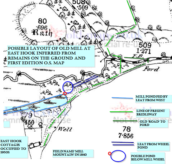
This suggests that the mill at East Hook was supplied by a leat from a tributary further upstream. From the bridleway you can see the remains of a leat rejoining the Pelcomb Brook just upstream of the footbridge.
Why was an agreement needed?
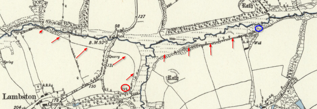
The agreement between Walesland and East Hook seems odd. All the water from Walesland flows into the Pelcomb Brook which passes East Hook land, so it is hard to see why an agreement would be needed assuming boundaries are similar to today.
The only solution I can come up with is that the Lambston Mill leat we see on nineteenth century maps was probably an earlier structure designed to supply water to augment this tributary. That would have needed an agreement from Walesland if the farm boundaries were similar to today’s boundaries.
I have shown what I think may have happened in the map below. The water flows down the leat from Walesland Water to the west. It then flows into a minor tributary coming from the south, from which it is taken by a second leat, flowing East, to the site of East Hook Mill.
I do not know a lot about mills, so if you are knowledgeable, and you have a better idea, please let me know.
Lambston Mill
The most recently operating mill in the parish was at Lambston. The tithe map of 1840 shows a named mill and the censuses of 1841 and 1851 list a miller and his family in residence. The 1818 OS map shows no buildings on the site and the 1887 OS shows only ruins although it does show the mill leat. It is possible that the operation was short-lived. There is no record of closure in newspapers of the time but the 1861 census lists an agricultural labourer as resident, so it may well have closed by then. The stream supplying the mill is very small and there is evidence on the ground of mill ponds. Presumably the water was held up and released when the mill was in use. The mill was also sited on the line of the leat described above, so probably received water from Walesland Water to the north and west.