This page gives details of the lost farms and cottages in Lambston which were shown on nineteenth century maps and have since been abandoned. The sites are also numbered on the map below which gives a better overview. Click on the small map for a larger one to appear.
North West part of the parish
The lost farms and cottages, working clockwise from the extreme north west of the parish include (1) Gibraltar. This was a farm located in the extreme north-west extension of the parish. Gibraltar no longer evident even as a ruin by the time of the first large scale Ordnance Survey of 1886. This farm may well have been also known as “The Rock of Gibraltar” because, in 1845 a Stephen and Mary Thomas of “Rock of Gibraltar” were baptised in Sutton Baptist Chapel. It seems unlikely that they would have come all the way from the Mediterranean to get married! In 1840 Gibraltar was shown as in the ownership of James Owen (Who also owned the land at Honey Hook) and occupied by William Thomas. (Tithe Map and Apportionment).
Just north of the junction of the Nolton to Rogeston road (Opposite present day Fairview Farm) an unnamed cottage (2) is shown on the 1840 Tithe map. It is shown on the 1887 O.S. map as Black Patch.
Coming east along the Nolton to Sutton road the Tithe Map shows a cottage(3) in 1840 located just to the south of where the present day smallholding of Cleavelands is situated. Again however the 1887 O.S. map shows no buildings at this location.
Another cottage (4) is shown to the north of the road between the junction with the West Lambston lane and the present day site of Homeland. (Built in — for the son of the owner of West Lambston). Once again this building is not shown on the O.S. 1:10,000 map surveyed in 1887. The O.S. edition revised in 1952 shows a series of buildings on the site of Homelands today.
Lambston Hill
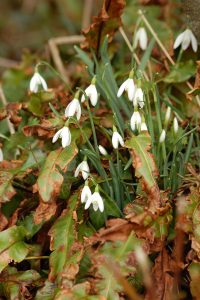
The Tithe Map shows a smallholding (5) at the base of Lambston Hill at the junction with the Nolton-Sutton lane. Overlooking the ford (Before the bridge was built) to the north west of the lane. The holding looks as though it might have been originally cut out of roadside waste – each of the associated fields are elongated along the road. The area today has a show of snowdrops and daffodils in the spring – perhaps a remnant of the garden.
The 1887 O.S. Map shows the unnamed building and from the census and local memory it was either known as Lambston Hill or Hills. It was abandoned in ??
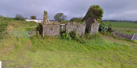
To the north of the back lane to Lambston about half-way between the lane and the parish boundary another abandoned cottage (6) site was associated with Glebe Farm, occupied at that time by the Reverend Andros LINK. It is not clear from the tithe map if this was the main farmhouse for the holding (of some 12 acres). Possibly the cottage behind the church (8) also in the occupation of Rev. Andros was the homestead. Certainly by the mid 20th century this second cottage was known as ‘Glebe’ – the land today is all part of Lambston Hall Farm. The cottage site was built over with farm buildings. 8-12
North-East part of the Parish
The farm (7) of Walesland (Shown on the Tithe map as Waseland, See also Names Page) still has farm buildings on it but they are modern. There is no sign of the farmhouse, garden and farm buildings shown on the Tithe and first edition O.S. maps. The farm is again part of Lambston Hall Farm at the time of writing. The family there recall the demolition of the then-derelict farm buildings in the 1970s after a long period of abandonment.
Lambston Village Lost Buildings and Cottages
On Lambston Green across the road from Lambston Hall the 1887 O. S. map 1:2500 map (Copied below) shows 12 ‘The Rectory’ . This may be the same building which is mentioned in Francis Jones’ Treasury of Historic Pembrokeshire as a Cock Pit LINK TO RECREATION PAGE. A little confusing and an issue which will bear further investigation.
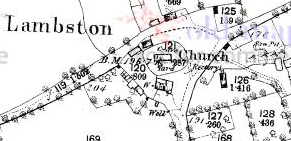
To the north of the church on the Tithe Map were four buildings which now have either disappeared or remain as ruins. (Photo) These include the cottage associated with Glebe Farm and another unnamed building on the south side of the road and a house and garden and a further unnamed building on the north side. One was used as a carpenter’s shop in the mid-to-late twentieth century (Personal communication David Thomas).
To the east of Lambston, the Tithe Map shows 13 Lambston Mill, located on a very small tributary of the Lambston Brook. Once again the 1887 O.S. map shows this site no buildings .
A short distance to the south east again the Tithe Map shows an additional two cottages (14)which seem also to be shown on the OS original drawings from the first survey in 1810. From this map however it looks as though these cottages were linked by lane to East Hook.
East Hook has both a lost farm and cottages
To the north and downhill from East Hook Farm, the Tithe Map shows an additional cottage in 1840 . This location today is marked by the remains of enclosures and a few trees. The buildings were shown as (15) East Hook Cottages on the 1887 O.S. Map and were apparently occupied.
In the extreme North-East corner of the Tithe Map, (16) Little East Hook is shown as an entirely separate farm of some 40 acres with a different occupier from East Hook. By the 1886 O.S. map however this site has been abandoned.
17
Coming south at the junction of the Sutton Back Lane and the Mount Lane the Tithe Map shows a cottage site (18). The 1887 O.S. Map also shows it but there is no record on the 1966 O.S. Map. The site is still marked today with ruined walls, trees and in the spring, with Snowdrops. It was occupied within living memory (Personal Communication David Marr).
The Tithe Map shows and names Sutton Lodge in 1840 but there is no evidence of any building at the entrance to the drive. By the 1887 O.S. map however a lodge (19) at the top of the drive is shown to the large house at Sutton Lodge. This had disappeared by the 1966 O.S. map.
At the junction of Mount Lane with the Sutton Lane the Tithe map shows a single building which was presumably the chapel at Providence. It is not however named and is not shown in the apportionment.
Portfield Gate and the Broad Haven Road
At Portfield Gate the Tithe Map shows eight dwellings; six cottages and two houses recorded, all on sites of present houses as far as I can see. The map and apportionment also shows a Poor House near the top of Temperness Lane. LINK
Coming west along the Haven Road from Portfield Gate, the Tithe map shows no dwellings, but a sale document from 1860 shows a building (20, not necessarily a dwelling) in the second field east of Plash Lane junction to the north of the Haven Road. This is not shown on the 1887 O.S. Map
Just East of the junction of the Haven road and the lane to Rosehill, Swelth Cottage (21) is named on the Tithe Apportionment to the north of the road. This is not shown by the 1:10,000 1887 O.S. survey.
Plash Lane
Coming back towards the centre of the parish there was a farm at Lower Plash (22) on the Tithe Map. This was shown as Ash Vale on the 1867 O.S. Map and is today marked by ruined buildings and a rusty dutch barn. It has a lane down to it from Plash Lane but in 1840 this is not shown on the Tithe Map, rather a “roadway” was shown along the southern border of the common which served Lower Plash and ran on towards Corner Farm.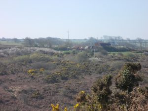
The Tithe Map shows a cottage in a different occupancy at Upper Plash (23) in the field just below the right angle bend in Plash Lane. There is a stretch of Lilac in the hedge along this lane today which perhaps marks the house location. There is no trace of this house or its garden on the 1887 O.S. Map.
Sutton Village; Lost farms and cottages
The Tithe Map layout of Sutton village LINK shows a similar road pattern to the present day with one farm house and one house between the Portfield Gate to Sutton Lane and Plash Lane in the area of Westfold Farm today. These houses are not named on the apportionment or map.
To the north of the Sutton Mountain Lane, between there and the Nolton Lane the Tithe Map shows one farm house, one cottage and one house and garden. These are similar to the houses shown on the 1886 O.S. map and on the mid 20th century O.S maps, but by the time the present houses were built in the 1980s they replaced modern farm buildings. The last surviving Tithe Map ruin was of the cottage across the road from the present day Sutton House. This was demolished in 2010.
Two additional buildings (Not dwellings) are shown in the garden of what is now Sutton House, one to the south west and one to the north east beside the Nolton road. Photographs from the 1970s show a large white farm shed in the location of the latter and there are the remains of what may have been a building wall at the location of the former.
Opposite Sutton House, in the location of today’s Westfold Cottage, the Tithe apportionment records a Methodist Meeting House . This seems strange since the chapel building at Providence is already marked on the Tithe Map (Though not identified as such in 1840 on the Tithe Apportionment).
East of Sutton
Coming along the lane to the east of Sutton and one field back to the southwest is the farmstead for a holding known in 1840 as (28) ‘Bounty Park’ (Link to information on Queen Anne’s Bounty). By the 1887 O.S.Map this was known as ‘Margam’ and where today the present road has a treed entrance to what is now a field gate, a farm track was shown as leading to the house. This house was demolished in the 1950s (Personal communication David Marr) and presumably explains the name ‘Margam View’ for the 6 council (Now mainly ex-council) houses in Sutton.
To complete the circuit of the parish, well north from the Sutton back lane and overlooking the Lambston Brook was (29)Lammack,. This was shown as the homestead of a 71 acre holding in 1840. The 1887 OS map shows this as a ruin. Closer to the road about half way up the straight towards the junction with Mount Lane the Tithe Map shows another (30) cottage north of the road, roughly where today there is an overgrown gateway. This is missing entirely from the 1887 O.S. map.