Lambston on Early Maps
I have been looking at Lambston very specifically for several years so I have tended to look at how the location is portrayed. County level maps became quite widely available in the sixteenth and seventeenth centuries. These maps are not necessarily entirely reliable sources of information. For early maps especially, many details are omitted because of lack of space, poor information or some active decision. The scale is small and even when we know that settlements or roads exist, they may well not be shown. Later maps are also drawn from earlier ones and may well perpetuate errors. I am not a map historian so may interpret these issues wrongly – if you know better please let me know.
County Maps
Lambston village was always shown in early maps in preference to Sutton or Portfield Gate. This is probably because the parish church was at Lambston. Lambston is almost always shown on county maps which omit nearby settlements which are now much more significant. The absence of settlements and roads may relate to the mapping system rather than that they did not exist. One exception is that early maps show the Haven Road running to Little rather than Broad Haven, the latter being a recent settlement.
Seventeenth Century Maps
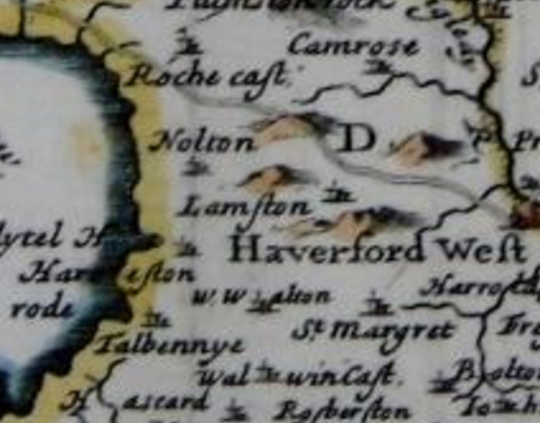
A county map by John Speed in 1650 shows Lamston (sic) with a significant range of hills to the north running to Roche. The area is shown as within Rowse Hundred. No roads are shown in the area. Settlements in the immediate area include Knowelton, Roche and Roche Castle, The Lyttle Haven, Harreston and West Walton. Broad Haven, Sutton and Portfield are not shown but Camrose is. Most of the shown settlements have church symbols. Other seventeenth-century maps by Speed and Kip show Lamston too close to the coast above a coastal-flowing river. They also show Camros, Nolton, Harrestonwest, Waltonwest and, in the sea, Broad Haven but not Little Haven.
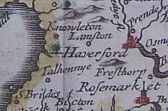
A small scale map by John Sellar in 1694 (above) looks as though it may be based on the Speed maps. It shows Lamston, Knowleton and Haverford but not Broad or Little Haven. The next settlement shown to the west is Talhennye.
Eighteenth Century Maps
1704 the Mordern County map shows Lamston and locally; Roch Castle, Camrose, Nolton, West Walton and Little Haven. It doesn’t show Nolton Haven, Broad Haven, Sutton or Portfield. The St Davids to Haverfordwest road is shown. No other roads to the west of Haverfordwest appear, partly because the name ‘Haverfordwest’ takes up the available room.
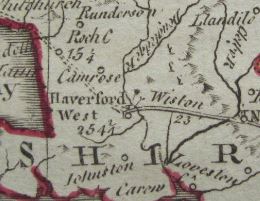
In 1764 a map by Kitchin shows Lamston as one of few settlements shown to the west of Haverfordwest. Unusually, another is East Hook. The map shows the roads from Haverfordwest to St Davids and from Haverfordwest to Dale but not to Broad or Little Haven.
Another 18th century map (titled ironically “A correct map of Pembrokeshire”) shows Lamston to the north of the Haverfordwest-St Davids road. Apart from Harroston closer to the coast no other settlements or roads are shown in the area.
A 1782 atlas map doesn’t show Lambston at all but shows Camrose and the Haverfordwest-St Davids road. Nolton Haven is the only settlement shown only to the west of Haverfordwest.
Nineteenth Century Ordnance Survey Maps
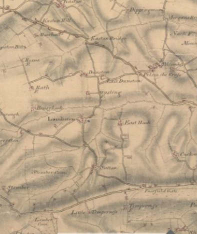
In the nineteenth century the first generally-available large-scale maps change the level and quality of information dramatically. The first large-scale maps of the area are the Ordnance Survey Surveyors’ drawings made in 1810. These maps are at about 1 inch to the mile and show Lambston, Sutton and Poorfield Gate. They show the out-of-parish ‘Poorfield’ as unenclosed. It was enclosed following an Act of Parliament in 1840. The drawings also name East Hook, Honeyhook and Wasling (Walesland) farms. What we know as Sutton Mountain is shown as ‘Lamber Common’. This area has no tracks or houses shown suggesting that Berry Hill, Sutton West and West Lambston are later farms.
The road network in the parish shown on this map is much as it is today. It shows an additional track north from East Hook with a branch to buildings to the west.
Once we are into the era of the Ordnance Survey maps, the variations in mapping become much more detailed and some are addressed in the section on Abandoned Farms and Houses.