The fields and field boundaries are often the oldest things still in everyday use within a parish. Certainly the basic pattern of today’s field boundaries is visible on the oldest (1818) estate map that I have been able to find. However, elsewhere, many field boundaries are known to date from Roman or even earlier times. This is especially true for boundaries which are used as the boundary of a parish.
The Field Boundaries that Define the Parish
In Lambston it is interesting that the boundary of the parish is always marked with a stream, road or field boundary. Even after the removal of many of the hedges in the area in the last 150 years, the boundary never crosses the middle of a field. I wonder if the pattern of land ownership is still in any way is influenced by the boundary of the old parish?
Reading the Significance of the Field Boundaries
I have no particular experience or expertise in reading the significance of size and shape of field boundaries but a few points have turned up from my researches.
Fenton in his travels in Pembrokeshire around 1811 speaks of survivals of ‘open-field’ systems. In this system each farm was allocated strips within a commonly-owned field and ploughed these independently of the strips ploughed by others in the village. In some places this system can still be seen in the pattern of landownership or management. In most cases, however, the strips were exchanged between owners, amalgamated by purchase or inheritance and generally consolidated to make more manageable-sized units.
Fenton mentions that into the 18th century open-field systems were in operation in Nolton and Roch just to the north of Lambston. It is therefore worth considering that the present field boundary layout in Lambston may be only about 300 years old. The 1840 Tithe Map shows some narrow unenclosed fields to the south side of Berry Hill Farm which may have been old strips.
There are several places where there are long, narrow field enclosures in the present day landscape. Some of these showed additional parallel fields alongside on nineteenth century maps which have since been amalgamated to make fields of a more convenient size and shape.
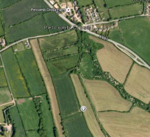
The most convincing are just over the parish boundary south of Pelcomb Cross. Here the field appears to show the typical curve that is associated with ploughed open field and attributed to the need to swing the oxen-powered plough at the end of each furrow. There are other long, fairly narrow fields that might be two or three strips (Which are also known as Selions or sometimes Quillions) which have been amalgamated in the past. Perhaps if I can find some older estate maps I can find out. Has anyone got anything among their deeds I wonder?
Enclosure
The other pattern that you seem to find in field patterns is that more recent, especially 18th and 19th century enclosures tend to be more regular, rectangular patterns and this is especially true where a parliamentary act has been made to allow the enclosure of common land or where the land has been enclosed from previously unenclosed ‘waste’. There was a parliamentary enclosure of the Portfield Common in 1840 and the record shows new enclosure to the south of the Haven road just over the parish boundary to the east.
There is no record that I can find that formal enclosures were authorised in Lambston (There is a reference to a proposed enclosure in Lambston in the County Archive but the archivists say the document cannot be found). I had originally thought that the large rectangular fields to the north of the parish at Honey Hook and Walesland show a more recent enclosure of waste. It would be easy to imagine late enclosures creeping up towards the wetter and rougher land around Naples and Keeston Moor(Over the parish boundary). However Walesland and Honey Hook are two of the earliest mentioned settlements and might be expected to have been enclosed earlier.
The 1810 O.S. Drawings and the 1818 1st edition O.S. maps show no tracks or buildings on Sutton Mountain. Perhaps Berry Hill and Sutton West are later enclosures into what had been waste. Both of these are shown as existing on the 1840 Tithe Map.
A quick comparison of the field boundaries of the parish between those shown on the 1887 O.S. map and those on the aerial photos on Google maps shows a significant reduction of field boundaries of well over ten miles. The picture seems to have been at least partly that as holdings were consolidated, there was a reduced requirement for stock proof boundaries, this coincided with a reduction in available farm labour so that stock were able to trample the grown out hedge banks and the resulting gappy bank was removed with modern machinery fairly easily.
If you think of ten miles of hedge-banks even degraded ones, as having perhaps 1 cubic metre of soil per metre that is 16,000 cubic metres that had to be put somewhere. In most cases I would think it went to fill in wet areas, especially if the work was associated with installation of tile or piped land drains. The resulting landscape is one with smooth field surfaces, which are easier to access for machinery, easier to plough and mow with modern machinery and this helps the farm to remain an economically viable unit.
The downside of this is a less visually interesting landscape, with fewer trees and less cover. This in turn means fewer farmland and woodland species – plants, insects, birds. It also means a far faster runoff with much less water being retained in trees, boggy areas, and hedges. This brings greater reliance on efficient drains to take the greater volume of water off the land and also to an increased area for surface run off and an increased risk of soil erosion. The downstream effect is that a much greater proportion of the rain that falls reaches the streams much more quickly and that increases downstream flood risk after heavy rain.
This is an area that will repay further investigation, if it is an aspect that interests you, let me know and I will tell you if I have new material.