Rights of Way today
There are two public bridleways (Public paths open for horse riding, cycling and walking) in the parish and 5 public footpaths. Of these both bridleways but only two of the footpaths are open and signed for use. The other three have no signage or gates and stiles. They remain however lines which members of the public have the right to pass over on foot.
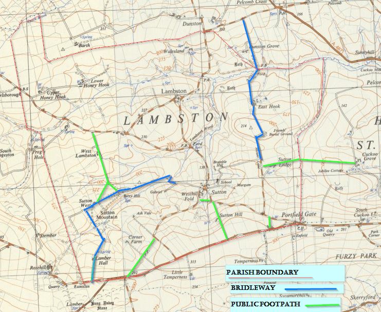
The map below shows public rights of way in the parish.
The Sutton Mountain Bridleway
This track passes across the ford and up the access track to Berry Hill passing on to Sutton West. It then cuts south across the wetter part of the common and passes Lamber Hall to join the Rosehill lane.
None of the early OS maps (1810 & 1818) show paths or tracks on Sutton Mountain. the track that does exist may be associated with building Sutton West and Berry Hill (between 1818 and 1840). Having said that, the 1762 Picton estate map shows farmed strips crossing Sutton Mountain. There must have been access at least on foot to the land much earlier.
Mr Turner of Berry Hill assures me that there is evidence that this route was a drove road for farmers bringing cattle to market in Haverfordwest. I have not been able to find any records of this and would welcome further information.
The 1889 twenty-five inch map shows the whole route as a track without specifying it as a Footpath.
The East Hook bridleway
This route links the ancient settlement of East Hook with both the St Davids road to the north at Pelcomb and with the networks of lanes around Sutton and Portfield Gate. Today only a bridleway it may have been more important in the past especially when there was a mill at East Hook. It would have provided access to the Friends’ Burial Ground from the 17th century.
The 1889 twenty- five inch OS map shows the route of the path as a track as far as the ford and bridge. Beyond that, the 1907 edition shows the path as FP (Footpath) on Dunston Grove land.
Sutton Lodge Path
Also joining Mount Lane a footpath (Open) passes east behind Sutton Lodge and passes out of the parish to Cuckoo Grove. None of the early OS maps show this as a path.
Between the Haven road and the Sutton Lane
There are two footpaths which link Sutton Lane with the main Broadhaven road. Neither is signed or apparently open at present. One is a very short path from Westhill farm to meet the Sutton Lane at a blue gate between the well and the entrance to Mount Lane. The other is a longer path from Sutton Hill Farm to meet the Sutton Lane close to the bend at the bottom of the hill. The 1889 twenty-five inch OS map shows the first but not the second of these paths.
Looking closely at the hedge-line from the lane you can see how there were once steps up the steep slope to reach the Sutton Hill path. The lane widens here and that widening is evident on the 1818 Evanton estate map. I have had a conversation with one elderly resident whose mother described the picture of the lady of Sutton Hill farm. She was passing down the path to school with her children behind her like a mother goose with her goslings. I believe the lady in question had no less than eighteen children!
Paths from Plash Lane
Just to the north of the point that the Sutton Hill path joins the Sutton Lane a second footpath crosses to meet Plash Lane. This path was legally diverted when Bass House was rebuilt in the last ten years. The 1889 OS map showed the route as a path but it is not signed or gated today.
Coming up Plash Lane to the right angle bend, there is a footpath passing straight on to meet the Haven road. This is the original line of Plash Lane as shown on the 1762 Picton Estate map. It is shown as FP on the 1907 twenty-five inch OS map.
West Lambston path
Finally there is a path linking Sutton Mountain with the road to Nolton via West Lambston. This path is closed with dense vegetation and unsigned. It starts with two paths forming an inverted Y off the north side of the common. The early OS maps show the paths as far as the stream but not on West Lambston land.