The Picton Estate Map
The PDF below is a poster produced for the 2017 Lambston Parish History Exhibition. From the records held at the National Library of Wales in Aberystwyth. It is the oldest, detailed map I have found of part of the parish.
It covers an area called ‘Sutton’. A lot of early documents refer to ‘The Manor of Sutton’ but individual farms in Sutton are not named until the mid-nineteenth century. Some documents simply refer to ‘land in Sutton’ or to ‘The Townred of Sutton in the parish of Lambston’. (Townred seems to have been a mainly Pembrokeshire word for a village and its surrounding farmland). In many cases there seems to be a clear distinction through time between Sutton land, East Hook land and Lambston land. All within the small parish of Lambston.
Land Ownership
The map only shows any detail for the land owned by the Picton Castle estate. But also shows adjacent ownership. It looks as though the land was divided up between Picton Castle, Sir William Owen Bart. (Orielton) and John Wogan Esq. (Boulston)
The Landscape
The field landscape is quite different to the present day hedged landscape. The majority of the fields shown are strips and ownership is spread all over the area in isolated blocks. Some fields are shown with dashed lines and some with solid lines, perhaps denoting enclosed or unenclosed land.
Some strips run right over the land which is today the common on Sutton Mountain. They are marked as ‘Arable’.
Roads
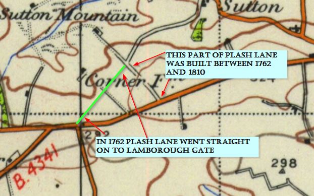
Plash Lane (on this map called Burdox Way) runs straight on to Lamborough Gate (The line of the present footpath).

The back lane from Sutton up to Mount Lane (on the 1762 map shown as ‘Quakers’ Way’) is missing.
Occupation
I assume that the different coloured fields reflect different tenancies, but the key to these is missing.
Conclusion
I wonder if this map is a glimpse of a much earlier farming system, perhaps fourteenth century, or even earlier, based on Sutton village. None of the farms, which were established by 1840, are shown. Gabriel*, Plash*, Sutton West, Berry Hill, Sutton Hill, Providence, Lammack, Margam, Corner Farm*, Lamber Hall all seem to have been established later. The landscape looks like a typical open-field system, which had disappeared in many Pembrokeshire parishes by the early eighteenth century but which Fenton records as still evident in Nolton around this time.
Some time between 1762 and 1810 the landscape, ownership, farm and field pattern completely changed in Sutton.
*Though Gabriel, Plash and the old name for Corner Farm, ‘Haythog Back’ appear as field names in 1762.